Assignment 2: A journey revisited
I considered a bike ride through the landscape with Lee
Friedlander’s “America by Car” as a contextual frame of reference which started
as an actual journey and became an imaginary journey through the edgelands. “Edgelands are part of the gravitational field of
all our larger urban areas, a texture we build up aped to escape as we hurry
towards the English countryside, the distant wilderness…If we can’t see the
edgelands, we can’t imagine them, or allow them any kind of imaginative life.
And so they don’t really exist.” Farley and Symmonds Roberts (2011:5) Researching
Friedlander’s images, I developed mine to include the bike frame and the idea
of flying through the landscape referencing Lee Friedlander’s America by Car.
My images were taken during summer afternoons
on journeys between home and Worksop; a distance of 20 miles by bike, using a
bridge camera to show the landscape and landmarks of the edgelands referencing
Friedlander’s style of topography.
Visual description of Lee Friedlander’s America by Car
Lee Friedlander exhibited 192 images from his work America by
Car at The Timothy Taylor Gallery, New York (2010) which toured America and
London, and also published photobook book to accompany the series of his journey
through most of the American States spanning a 15 year period. Using a style described
as social documentary, he used the medium of photography to record the
topography of a social landscape taken from the driver’s seat of American
budget hire cars showing the driver’s perspective of urban and roadside
American life. According to Whitney’s
Museum of Modern Art “the car and highway
represent adventure, freedom and wanderlust.” (MoMA)
Most
of his images show parts of the car such as the dashboard, windscreen, side
window, rear view and side mirrors and essentials such as a steering wheel.
This allowed
for special effects such as foreshortening (cutting out the middle
of the image) e.g.
Montana 2008 where the top of the dashboard formed a straight line
at the bottom of the
notices.
Friedlander also used juxtaposition such as in Nebraska (1999) where he photographed a
herd of cows through the side window (making a natural frame) and including the leather
door panel in the shot. The viewer is left to make their own comparisons of the image
whilst the viewpoint is familiar to most travellers.
Friedlander
compared the colours and textures of the natural foliage of the tree with the
man-made
door panel material in Arizona 2001. This is repeated with images such as his
car’s shadow infront of a car transporter or war memorials against a door
pillar.
Friedlander’s use of the super Wide Angled Hasselblad and
square format gives rise to unusual perspectives which Whitney’s MoMA likened
to Robert Frank’s work. The MoMA exhibition included many photographs for
maximum impact and to give viewers the feeling of driving their car through the
landscape. Friedlander grouped together his images in typologies such as rural,
churches etc. rather than as a journey through America.
He used reflection in the mirrors to reveal a different
landscape or a person (sometimes self-portrait). The limitations of using the
car as a frame reveal buildings in which perspective is uncorrected that adds
to the chaotic and trapped feeling. Friedlander’s images could be described as
cold and static, as if the outside world is being viewed from the inside
comfort of the car.
Critical writing about the series
Sean O’Hagan, writing in The Guardian (2011), suggested that
Friedlander’s America by Car fits well with earlier work rejected by Harper’s
Bazaar in 1964. This included images of expensive, upmarket cars for example in
a field of telephones or shot through a phone booth or hidden behind a stack of
tyres. Friedlander exhibited “New Documents” in 1967 at MoMA which showed his
style as “social documents” – “challenging and often playful investigations of
what photography could be; a slap in the face of the high seriousness of the
American Landscape tradition.” Friedlander
invited the viewer to question what they were seeing. O’Hagan describes
Friedlander’s America by Car series as disorientating for the viewer, because
of the punctuation of the window frames although the viewer sees past this to
the view.
Karen Rosenburg (New York Times 2010) on the other hand,
suggests that Friedlander “knows that cars are essentially illusion factories –
to wit “Objects in the mirror are closer than they appear.”” (Rosenburg, 2010) She paralleled Friedlander’s
work to old Hollywood road scenes with moving projected roads and stationary
cars and argues that the car obstructs the picture view. Rosenburg compares
Friedlander’s work to photographers such as Eugine Atget and Walker Evans with
regards to the layering of images in shop windows and mirrors and use of signs.
Barlow (2014) explained that Friedlander was influenced at the beginning of his
career by theses masters of photography. Rosenburg argued that Friedlander’s
images did not contain many contemporary images of political and social subject
matter, (referencing an image which contained an “Obama Biden” bumper sticker)
and so perhaps he was not interested in this subject. She also criticised his
lack of inclusion of all 50 states and questioned why he did not visit them
all.
Barlow (2014) biographer of Friedlander for Grove Art
Online suggested Friedlander
suffered from painful knees and required knee surgery whilst photographing this
body of work. The question raised by some critics is that photographing from
outside the car gives a different slant on subject matter. I found this series
compelling as it gave a different, obstructed perspective of the landscape and
the more I considered an image, the more Friedlander’s skill revealed the
social landscape.
How Friedlander’s series relates to my work
Considering how to adapt this style of photography to include
my bike as the vehicle, I deliberated using a gopro camera to take stills. Friedlander’s
images were shot on film and can be produced to a reasonable size although pixelated
gopro images could look like a modern interpretation. Better quality images
with a camera I could manipulate outweighed the accessibility of the gopro; the
only difficult shot to include being the front tyre view. However, working
digitally, unlike Friedlander, several shots were possible to obtain the
correct perspective of the bike in the landscape. Friedlander used a super wide
angled Hasselblad which produced square images.
Initially, I included only the handlebars, imagining I was sitting
on a bike as opposed to being in a car; however, this was limiting and ordinary
and I developed a style of 3 different views of the bike to intensify the
dynamics. I found the idea of foreshortening an interesting idea, and included
this within a couple of images – namely Archway House (image 5) and Worksop
Pumping Station (image 9). Following my tutor’s suggestion of keeping the
series to a few bike views (such as through the cables, over the rear tyre and
with the suspension fork to one side) made the series more cohesive. I included
an action shot self-portrait on the bike, although it appears in the middle
rather than at the end of the series to show that I am riding over the
landscape and it continues the momentum. Friedlander used different seasons and
weather conditions; mine is based over a short time span and so for cohesion, I
kept to shooting in the afternoon.
My journey
The first mile took me through different housing
estates in the village and onto an old
railway line (originally owned by the
Great Central Railway) and ran between 2 collieries,
with a tarmac surface
where a few teenagers hang out and the rider often meets dogs off
leads,
changing graffiti on the bridge and desire paths people make as they take the
shortest route up and down the unstable banks rather than use the gently
sloping path.
Now owned by Sustrans, a UK charity who enable “people to travel
by foot, bike or public
transport for more of the journeys we make every day.” (Sustrans, 2015)
 |
| Image 1 |
The sunlight on the yellow and blue
paint provided a good contrast to the bike. The curves of the cables complemented
the curves on the graffiti. I explored various angles and bike parts against
the wall and felt this created a strong image. As a first image, I aimed to
show the mode of transport and give the viewer a sense that it was not a
journey through a “picturesque” part of the country. “Graffiti is part of the
visual noise of our age, in the same way as broadsheet ballads once supplied
the background buzz of earlier centuries, and is perfect for the mobile gaze;
the short emphatic, florid statement of name, protest or allegiance, an
impression meant to be made at high speed.” (Farley and Roberts Symmonds 2011:124) Over time, the graffiti on these bridges are painted over and repainted
with different names or artwork or left to fade as people move on.
 |
| Image 2 |
As I arrived at the second mile
marker, the tunnel walls were covered in graffiti. This was the furthest the
graffiti artists came out of the village. The more experienced mountain bikers
who use this track have made a desire path to add a skills section to their
journey or shave seconds off their “Strava time[1]”
by cutting out the steep hairpin bend. They mount the kerb and join the rocky
path which takes them to the tunnel. This image shows the sudden descent
required to the tunnel along the desire path. The direction of the crank
provides a leading line and the pedal is juxtaposed with the tunnel (similar to
Friedlander’s foliage with door material).
Over time, sections of the railway have been moved and other
tracks added. I found the idea of “desire paths” or paths of least resistance
an interesting concept of planners versus people in developing the landscape. (Farley and Symmonds Roberts, 2011:24) explain this as a “”bottom up”
system against the “top down” methodology of the planners.” Walking this area
always reminds me of how rights of way have evolved.
The track turned alongside Rainworth Water on one side and
Rufford Colliery workings on the other. Great care is taken to keep the public
out and deter would be adventurers with wire (often cut) and trees
strategically placed across the track to prevent the cyclist from straying onto
the pit land.
 |
| Image 3 |
After a couple of miles on land owned
by the Forestry Commission, (Sherwood Pines) my journey took me across Eakring
Road; a sandy road, impassable by cars and now lined by large rocks in places
to keep out the notorious abandoned, torched cars. It does still hold surprises
– Sat Nav’s send the unknowing holiday makers along this road to Centre Parcs! Over the years, steel barriers have been
removed by opportunist scrap metal merchants and again, the barrier is now
large rocks.
I turned the bike round and looked back at my journey as the
view was more descriptive. Does it matter that it is not a truthful
representation? I think not because if I was marketing the image for the
Forestry Commission, I would argue that it is more “picturesque” than looking
forwards. This image uses the idea of the doorpost framing to obstruct the
view.
The view of Vicar Water Country Park is
dominated by the colliery headstocks (the tallest in Europe) – a listed
building which locals are fighting to save from demolition and a prominent view
in the area. The pond dates from the Victorian times and sits in the middle of
colliery spoil heaps, now converted into a country park and popular
with many different users; walkers, cyclists, horse riders and fishermen.
 |
| Image 4 |
By framing the towers between the
cables, I aimed to make the headstock towers the focal point and show trail
user on the periphery of the image, similar to Friedlander’s framing with the
windscreen and side window.
The track passes the edge of
Clipstone Colliery and into rural countryside, past a pub, across a set of
traffic lights and through the grounds of Archway House, formerly a hunting
lodge and now a self-catering cottage. Originally built by the 4th
Duke of Portland in 1842, it was a copy of the gatehouse at Worksop Priory.
Being situated in the heart of Sherwood Forest, it is decorated with statues of
Robin Hood, Little John, Maid Marion, King Richard, Friar Tuck and Alan a Dale.
This was positioned on the old Broad Drive so a view of the centre tree was
visible through the middle of the building.
The frame of the bike lends itself to the shape of the
building, as if creating a frame for the image. The children’s slide repeats
the shape of the bike frame. This picks up Friedlander’s foreshortening idea,
cutting out the middle ground.
 |
| Image 5 |
Friedlander included self-portraits through his
car window or in the mirror. That was impossible to do on my bike but there are
other methods of taking a self-portrait!

For those who wish to enter the National Trust’s Clumber Park
grounds without their car, a carpark is located on the main road out of
Worksop. Cyclists and walkers use the Sustrans track to enjoy the ducal park or
carry on to Lincoln via a link to the number 6 trail. This seat is less than
half a mile from the carpark and I am amazed at how much litter accumulates in
the summer. There are no bins, but neither are there any “please take your
litter home” signs. However, when I came to reshoot this image, the original
litter had been cleared and someone had left a bottle on the bench.
 |
| Image 7 |
This view, taken through the
suspension forks is similar to Friedlander’s division through the windscreen.
On one hand there is a scenic view down the track and on the other is the bench
with litter.
The track eventually joins a tarmac road and heads downhill,
past a monkey tree and over a classical bridge built in the 1760’s which is under
threat from cars driving into the balustrades and subsidence from the mines
which run underneath it. Travelling through the park and following the signs, I
saw Truman’s lodge in the distance, an entrance to the park built in 1789. I
was surprised to learn that the formal gardens of Clumber Park were designed by
William Sawrey Gilpin, nephew of William Gilpin who turned from landscape
painting to landscape gardening in later life.
The track turned just before the lodge, meaning I only caught
a glimpse of it in the distance. It traversed through the undergrowth and out
past a golf course. Once we joined the tarmac road towards Worksop, the scenery
became more edgelands and then urban.
 |
| Image 8 |
In suburbia, the signposting became confusing as it was
stickers or signs on lampposts and bus stops. The tarmac road surface meant I
could travel faster but also had to avoid parked cars, kids playing in the streets and
families drinking beer on their sofas in the front gardens. Allowing for some
distortion due to the shooting angle, I re-examined the telegraph pole and it
really is bent. This image picks up the idea of the handlebars being the top of
the dashboard and the view from the windscreen.
 |
| Image 9 |
The route headed towards the
Chesterfield Canal with its industrial heritage, past Bracebridge Pumping
Station built in 1881 to pump sewage; now listed building sold in July 2015,
awaiting a new lease of life from developers. Again, I experimented with
perspective and foreshortening.
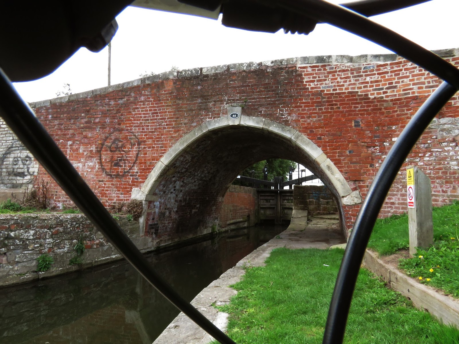 |
| Image 10 |
Bracebridge Bridge (no 44) traverses
Kilton Top Lock across the Chesterfield Canal; built to link Chesterfield with
the River Trent (to export coal, lead, timber and millstones and import wine,
wool, fresh groceries, oil, rice and tobacco). The canal, (45.5 miles in
length) is narrow and winding and horse drawn cuckoo boats had to be used
(peculiar to this canal).
The factory was built at the time of
a prosperous age and was still in use. The canal is being restored so looked as
if I was approaching a more enterprising area of the town. Friedlander’s images
of towns have buildings in which the perspective is uncorrected. I tried
correcting the perspective by taking two images and layering one over the
other; deciding the original was a more accurate representation of Friedlander’s
work because the world is distorted from low down. I included the skid mark
because it shows something happened here.
 |
| Image 11 |
The trail crossed a set of traffic
lights and passed through another residential area which looked acceptable. Sandhill
Lake (an old sandpit), my destination, backs onto this neighbourhood. As I reached
here on my first journey, I heard domestic arguments and saw someone taking
photos through the window of a flat. On my return visit, the flat was quiet and
had been put up for rent suggesting that the people had moved out.
 |
| Image 12 |
Newspaper reports suggested a large sum of money had been
spent on making this lake a destination for people to enjoy. In the afternoon
sunshine it looked peaceful and tranquil. I felt this was a fitting return
point for my journey.
Over a longer project, I could use different bikes for
different landscapes – road bike for road shots and mountain bike for off road,
hybrid for anything else. I don’t have mirrors on my bike but could purchase
and fit to my hybrid, although this image would not fit in with the cycling
enthusiasts in this country! However, with more time I could find a vintage
bike and reflect on how the social landscape has changed. Instead I
experimented with reflection in different ways such as the television shot and
using shiny parts of the bike. In hindsight, I should have used a shop window
in Worksop. I tried including my own shadow in reshoots which I felt did not
produce a strong image although I did manage a self-portrait. Friedlander
presents square images. My final submission is now landscape format because it
suits the image. Again, in retrospect, I could try a square format. At the time
of shooting I was unaware that my camera could be altered.
References
Barlow (2014) http://www.oxfordartonline.com/subscriber/article/grove/art/T029946?q=lee+friedlander&search=quick&pos=1&_start=1#firsthit
Esquire. (2011)
Lee Friedlander by car. Esquire. 13th September. [online]. Available
from: http://www.esquire.com/lifestyle/g635/lee-friedlander-america-by-car-photos/?slide=1 [last accessed 8th September 2016].
Farley, P. and Symmonds Roberts, M. (2011) Edgelands: Journeys into England's True Wilderness. London: Vintage.
O’Hagan, S. (2011)
Lee Friedlander: America by car and the new cars 1964 – review. The Guardian. [online] 4/9/11.
Available at: http://www.theguardian.com/artanddesign/2011/sep/04/lee-friedlander-photography-review [last accessed
21/07/2016].
Rosenburg, K. (2010) Landscapes framed by a chevy. The New York Times. [online] 2nd September. Available from: http://www.nytimes.com/2010/09/03/arts/design/03car.html?_r=0 [last accessed 9th
September 2016].
Sustrans (n.d.) About us [online]. Website. Sustrans
Available from: http://www.sustrans.org.uk/about-us [last accessed 21/07/16].
Bibliography
(Anon.) (n.d.) Part 4: 19th and 20th
Century Worksop. [online] Worksop Heritage Trail.org.uk. [online] Available
from: http://www.worksopheritagetrail.org.uk/resources/worksop_history_4.pdf [last accessed 21/07/16].
(Anon.) (2002) Clumber Park Nottinghamshire [online]
Bassetlaw District Council. Available from: https://www.bassetlaw.gov.uk/media/66373/HistoricClumberPark.pdf
[last accessed 21/07/15].
(Anon.) (2014)
Worksop: Popular beauty spot Sandhill Lake to get a £100,000 makeover. Worksop
Guardian [online]. 2nd April.
Available from: http://www.worksopguardian.co.uk/news/local/worksop-popular-beauty-spot-sandhill-lake-to-get-a-100-000-makeover-1-6537514 [last accessed
21/07/16].
(Anon) (2015) BBC
Weather [online] Website. Available from: http://www.bbc.co.uk/weather/2639687
[last accessed 21/07/15].
BBC Nottingham
(2008) Local History Clumber Park Bridge.
[online] Website. Available from: http://www.bbc.co.uk/nottingham/content/articles/2008/08/15/clumber_park_bridge_feature.shtml [last accessed 21/07/16].
Bradner, L. (2010)
The Photo File: Lee Friedlander takes aim at the passing scenery. Los Angeles Times [online] 26/09/2010
Available from: http://articles.latimes.com/2010/sep/26/entertainment/la-ca-car-20100926 [last accessed 21/07/16].
Chesterfield Canal
Trust. (n.d.) The Chesterfield Canal, a
virtual tour. Part 5 Worksop to Retford. [online] Website. Available from: http://www.chesterfield-canal-trust.org.uk/virtualw.shtml [last accessed
21/07/16].
Friedlander, L. (2011) Lee Friedlander:
America by Car in pictures. The Guardian. 2nd September. [online]
Available from: https://www.youtube.com/watch?v=d9aK-DtsWw0by-car-in-pictures [last accessed
8/8/15]
Harding, C.
(2013) The surprising link between
cycling and photography [online]. Website.
The National Media Museum. Available from: http://blog.nationalmediamuseum.org.uk/2013/07/23/cycling-and-photography/ [last accessed
21/07/16].
Henry Wessel: The
view from the driver’s seat [user-generated content, online] Creat. San
Fransisco Museum of Art. (2016) 1 min,54 secs.
http://www.sfmoma.org/explore/multimedia/videos/295 [last accessed 21/07/16].
Nandi, T and R.
(2012) History of Archway House, Sherwood
Forest. [online] Website. Available from:
http://www.archwayhouse-sherwood.co.uk/history.htm [accessed 21/07/16].
Nottinghamshire
County Council (2013) New leisure trail
opens between Bilsthorpe and Sherwood Pines [online] Nottinghamshire County
Council. Website. Available from: http://www.nottinghamshire.gov.uk/pressreleases/show/new-leisure-trail-opens-between-bilsthorpe-and-sherwood-pines [last accessed
21/07/16].
Piebenga, S.
(1994) William Sawrey Gilpin (1762-1843)
Picturesque Improver. Garden History Vol 22 No 2 Winter 1994 [online]
Available from: http://www.jstor.org/stable/1587026?seq=1#page_scan_tab_contents
[last accessed 21/07/16].
Sustrans (n.d) Millennium Mileposts. [online] Website.
Available from: http://www.sustrans.org.uk/scotland/national-cycle-network/about-network/millenium-mileposts [last accessed
21/07/16].
Symcox, J. (2015)
Will Clipstone Colliery headstocks be saved? Community group plans 100mph zip
line in ambitious regeneration plan. Mirror
[online]. 2nd March. Available from: http://www.mirror.co.uk/news/uk-news/clipstone-colliery-headstocks-saved-community-4851729
[last accessed 21/07/16].
Taylor, T. (n.d.)
Lee Friedlander: America by car and the new cars 1964 [online] Available from: http://timothytaylorgallery.com/exhibitions/lee-friedlander-america-by-car-the-new-cars-1964/info/ [last accessed 21/07/16].
Overall, my assignment was well received. It needs some fine tuning which will stand me in good stead for the critical review (assignment 4) and hopefully progressing onwards through level 5 towards 6.
"This is a thorough assignment submission Nicola with plenty of research,
investigation and review. Your energetic interest in your project carries the
reader/viewer along with you. I’m going to make several suggestions for
development but that's because there’s enough here to work with, so please take
it as a compliment and don’t forget to respond in your reflection on the tutor
report." Tutor feedback Assignment 2 September 2015
Points for development
Bullet pointed from tutor comments:
- start with Friedlander's America by Car" as a contextual frame of reference" (tutor report) which is a bike ride through the landscape.
- Add in depth reflection of Friedlander's America by Car to my Assignment
- Consider illustrating with one of Friedlander's images (could link to his work on blog to avoid copyright issues)
- Short intro- places and dates etc
- Visual description of Friedlander's work (mention wide angle of SWC Hasselblad)
- Evidence some awareness of existing critical writing of Friedlander's series
- My response and how it relates to my work.
- Move my ideas, plans and parameters to "assignment prep" on blog
- Reshoot 3 images
"There’s a strong development through the series from the first shot of a bike in front of some graffiti to some really quite exciting images where we’re starting to feel a sense of being unstable, of flying through the landscape on this machine. For me this begins at number 3 with the obstructions right in our path, and continues on to 4 and 5 where the framing feels fresh and natural and speaks most directly to Friedlander’s work. In 6 you’re resting, which does drop the tempo of the viewing experience somewhat. It’s not a bad shot but I would like to find something more unexpected here, some subtle gesture of the body perhaps to express the idea. Then off again to Number 9 with the crazy telegraph pole and wires and no hands and then careering through 10 to a couple of more sedate images for 11 and 12." (Tutor report, September 2015).
I acknowledge the image of me map reading should perhaps be changed for one where there is momentum - in the form of an action shot. I had not considered it as breaking up the series or slowing it down. I explained in my notes that I was intending to use different parts of the bike in my images. This was to break away from what Friedlander had done so I did not feel like I was copying his idea. Friedlander uses a formula of images that work for him and I had not appreciated that by contextualising my ideas, my work could be similar without "copying". It will not be an issue to reshoot these to give the assignment a more "finished" feel. By sharing development work with a wider audience, I would get other points of view on how someone interprets a series. Having retaken 3 images, I see now that this works more cohesively as a series.
My tutor suggested that perhaps my journey worked as an imaginative one. I had not considered this idea although by the time I had finished reshooting, it was a representation rather than an actual journey. With my riding partner out of action through surgery, I spent a fair amount of time putting the bike in the back of the car and getting it back out again to reshoot, much to the amusement of several passing cyclists! Revisiting the quote I used in my blog on Marion Shoard's definition of Edgelands, I can see how this would give me a reason to portray an imaginary journey;”Edgelands are part of the gravitational field of all our larger urban areas, a texture we build up speed to escape as we hurry towards the English countryside, the distant wilderness.[…] If we can’t see the edgelands, we can’t imagine them, or allow them any kind of imaginative life. And so they don’t really exist.” Farley P, Symmonds Roberts, M (2011 p5)
Reference
Farley P, Symmonds Roberts, M (2011) Edgelands: Journeys into England's True Wilderness, Vintage
August 2015
Assignment 2: A journey
Journey ideas
- 20 mile bike ride through edgelands of Nottinghamshire (developed idea)
- edgelands walk through wilderness behind village. Rufford Colliery closed but used for coal washing. Bridleway and access changes periodically. Evidence of desire paths, people sleeping rough, territory, wires cut for access. Some developed into a nature reserve (SSSI) and golf course. (Edgelands, Topography)
- Based on work by Mark Power’s different endings (2003-6) looked at 14 A and B classification road endings and beginnings, visit industry or houses near to road junction build up image of Mansfield. Used google street view to plan a route. (Psychogeography)
- Park and Ride bus journey. Inspired by work from Nottingham Trent University degree show and Lee Friedlander’s work. Abandoned after walk for Exercise 2.5 Text in Art. Felt uninspired. (Edgelands, Topography)
Journey plan
Usual summer evening journey by bike to Clumber Park (owned
by the National Trust) and back. Extending the route by 10 miles takes in the edgelands
of Worksop; to examine human interaction in shifting landscapes. Land steeped
in legend and folklore although not really touristic. Sustrans national trail 6
runs through area and plan to follow route from home to Worksop.
By photographing along a linear route and recording the
planned images, the journey time would be 5 to 6 hours with stops to take
photographs and cycling home in the dark. Have to reshoot if necessary.
First set of parameters:
·
Use
a bicycle. Interestingly, Niepce assisted with evolving the bicycle before
photography developed as an art medium. Women took to riding bicycles with
cameras attached to cases on the handlebars and cycling was promoted for
photographers as a means of transport in the “Illustrated Photographer” in
1869.
·
Take
photos at every mile interval measured by cycle computer to ensure subject
matter was systematically generated
·
Take
photograph at every number 6 signpost as record of landscape and looking for
the signs enabled me to gain an understanding of the difficulties in following
the route from a traveller’s perspective.
·
Use
bridge camera to enable me cover more distance quickly
·
Photograph
using similar viewpoints from bike. Shoot to side or forwards but not backwards
because the journey should show where I was going. Experiment using handlebars
in the frame.
The total number of photos taken on my first journey was 274!
From this, I developed a contact sheet of 12 images and developed my images
based around these locations.
Original 12 images

Development work
Lee Friedlander (America by Car 2010) presents 200 images
taken on his journey through America. Using a documentary style of photography
to record the topography of a social landscape taken through the car and by
depicting parts of the car within the frame, he distorted the landscape and
reflected some of his personality as a photographer into the image. He created
his own world to take photographs from. Sometimes the door frame separates the
image and occasionally he juxtaposes an object with part of the car’s interior.
For example, he compares the foliage of the tree with the door panel material.
He uses reflection in the mirrors to reveal a different landscape or a person
(sometimes self-portrait). The limitations of using the car as a frame reveal
buildings in which perspective is uncorrected that adds to the chaotic and
trapped feeling. Friedlander’s images are cold and static, as if the outside
world is being viewed from the inside comfort of the car.
Considering how to adapt this style of photography to include
my bike as the vehicle, I deliberated using a gopro camera to take stills.
Friedlander’s images were shot on film and can be produced to a reasonable size
although pixelated gopro images could look like a modern interpretation. Better
quality images with a camera I could manipulate outweighed the accessibility of
the gopro; the only difficult shot to include being the front tyre view. However,
working digitally, unlike Friedlander, several shots were possible to obtain
the correct perspective of the bike in the landscape. Initially, I included only
the handlebars, imagining I was sitting on a bike as opposed to being in a car;
however, this was limiting and ordinary and I developed a style of showing many
different views of the bike to intensify the dynamics. Using a low view point gave
a fairly limiting view which I felt was similar to Friedlander’s idea.
Henry Wessel, explained that he started taking images whilst
driving around in his car. Once he stepped out of his vehicle and explored the
area, he discovered the landscape was radically different. I associate with
this as when using Google street view and the OS map to research my route,
although some of the images looked similar to google, the detail and the
atmosphere of the housing estates in Worksop were much rougher than perceived.
Some google street view images had not been updated since 2009 although nearby
was updated in 2014.
Toby Smith (Walk the HS2 line project) presented a session at
the Photography Show NEC this year. This large scale project walking London to
Birmingham (140 miles in 10 weeks) documented the current social landscapes such
as derelict buildings, personal graffiti or converted buildings and people’s
livelihoods which could be affected with the HS2 line. He spoke of the
importance of selecting parameters when faced with a large scale project. I set
some parameters and when reshooting found that if the original situation had
changed, I could go back to the previous mile marker (one of my parameters) to
illustrate a different scene. Toby’s images were colour, shot in film and
square (like Friedlander’s) which complemented the composition. As a series of
images, the lighting, weather and seasons changed over the period of time. I
re-shot in the afternoon so my images were still in time order with it being a
small journey. He suggested always using
a tripod to give good quality images, although in this situation the tripod legs
would have been inconvenient. However, to maintain a good quality of image, I
set the shutter speed to 1/125s so that camera shake was not present. In
hindsight, maybe a gorilla pod attached to the bike would work.
The journey
The journey began at 4:30pm on a beautiful sunny, warm
afternoon. The sort which kept the insects high, brings out the scent of the
wayside plants and trees and gives everything an orange tint, reminiscent of
the colours in a romantic Victorian landscape painting. The clouds added texture to the sky. My bag
was packed with the essentials – lights, first aid kit, puncture repair kit and
bike spares, snack bars, extra drinks, a jersey, riding glasses, a Landranger
Ordnance Survey map, phone, loose change and a bridge camera complete with
spare battery, memory card, lens cloth and waterproof bag in case of the rain
shower which did not appear on the BBC weather app.
The first mile took me through
different housing estates in the village and onto an old railway line
(originally owned by the Great Central Railway) and ran between 2 collieries,
with a tarmac surface where a few teenagers hang out and the rider often meets
dogs off leads, changing graffiti on the bridge and desire paths people make as
they take the shortest route up and down the unstable banks rather than use the
gently sloping path. Now owned by Sustrans, a UK charity who enable “people to
travel by foot, bike or public transport for more of the journeys we make every
day.” http://www.sustrans.org.uk/about-us (accessed 4/8/15)
 |
| Image 1 |
The sunlight on the yellow and blue paint provided a good
contrast to the bike. The curves of the cables complemented the curves on the
graffiti. I explored various angles and bike parts against the wall and felt
this created a strong image. As a first image, I aimed to show the mode of
transport and give the viewer a sense that it was not a journey through a
“picturesque” part of the country. “Graffiti is part of the visual noise of our
age, in the same way as broadsheet ballads once supplied the background buzz of
earlier centuries, and is perfect for the mobile gaze; the short emphatic,
florid statement of name, protest or allegiance, an impression meant to be made
at high speed.” Farley, P Roberts Symmonds M (2011, p124) Over time, the
graffiti on these bridges are painted over and repainted with different names
or artwork or left to fade as people move on.
 |
| Image 2 |
Over time, sections of the railway have been moved and other
tracks added. I found the idea of “desire paths” or paths of least resistance
an interesting concept of planners versus people in developing the landscape.
Farley P and Symmonds Roberts M (2011 p24) explain this as a “”bottom up”
system against the “top down” methodology of the planners.” Walking this area
always reminds me of how rights of way have evolved.
The track turned alongside Rainworth Water on one side and
Rufford Colliery workings on the other. Great care is taken to keep the public
out and deter would be adventurers with wire (often cut) and trees
strategically placed across the track to prevent the cyclist from straying onto
the pit land.
After a couple of miles on land owned by the Forestry
Commission, (Sherwood Pines) my journey took me across Eakring Road; a sandy
road, impassable by cars and now lined by large rocks in places to keep out the
notorious abandoned, torched cars. It does still hold surprises – Sat Nav’s
send the unknowing holiday makers along this road to Centre Parcs! Over the years, steel barriers have been
removed by opportunist scrap metal merchants and again, the barrier is now
large rocks.
 |
| Image 3 |
This was photographed with my bike
turned round and looking back at my journey as the view was more descriptive. Does
it matter that it is not a truthful representation? I think not because if I
was marketing the image for the Forestry Commission, I would argue that it is
more “picturesque” than looking the other way.
The view of Vicar Water Country Park is dominated by the
colliery headstocks (the tallest in Europe) – a listed building which locals
are fighting to save from demolition. These are a prominent view in the area.
The pond dates from the Victorian times and sits in the middle of colliery
spoil heaps which have been turned into a country park. It is popular with many
different users; walkers, cyclists, horse riders and fishermen.
 |
| Image 4 |
In the original image, I had captured
a horse and cart against a sign for multi - users (bikes, pedestrians and
horses). During the reshoot, I saw several pedestrians and cyclists. By framing
the towers between the cables, I aimed to make the headstock towers the focal
point and show trail user on the periphery of the image, similar to Friedlander’s
framing with the windscreen and side window.
The track passes the edge of
Clipstone Colliery and into rural countryside, past a pub, across a set of
traffic lights and through the grounds of Archway House, formerly a hunting
lodge and now a self-catering cottage. Originally built by the 4th
Duke of Portland in 1842, it was a copy of the gatehouse at Worksop Priory.
Being situated in the heart of Sherwood Forest, it is decorated with statues of
Robin Hood, Little John, Maid Marion, King Richard, Friar Tuck and Alan a Dale.
This was positioned on the old Broad Drive so a view of the centre tree was
visible through the middle of the building.
 |
| Image 5 |
The frame of the bike lends itself to the shape of the
building, as if creating a frame for the image. The children’s slide repeats
the shape of the bike frame.
Passing public art in the form of a sculptured millennium
mile post marker on the Sustrans trail, the cyclist is reminded how far they
have come and still have to go. Designed by Andrew Rowe, a Welsh Artist, it is
“based on the nautical and industrial heritage of his native Swansea.” (http://www.sustrans.org.uk/scotland/national-cycle-network/about-network/millenium-mileposts
accessed 4/8/15)
Sustrans highlight that it is one of four available (designed by an English,
Scottish, Welsh and Northern Ireland sculptor) and developers of tracks tend to
favour those from their own country of origin. I had already passed another
Welsh statue at Clipstone and there is a record of another Welsh marker further
along my journey, so with 3 Welsh mile marker posts within 15 miles, I have to
disagree with the comment from Sustrans.
 |
| Image 6 |
Friedlander included self-portraits
through his car window or in the mirror. I included a long shot across the bike
showing the map with mile markers highlighted.
For those who wish to enter the National Trust’s Clumber Park
grounds without their car, a carpark is located on the main road out of
Worksop. Cyclists and walkers use the Sustrans track to enjoy the ducal park or
carry on to Lincoln via a link to the number 6 trail. This seat is less than
half a mile from the carpark and I am amazed at how much litter accumulates in
the summer. There are no bins, but neither are there any “please take your
litter home” signs. However, when I came to reshoot this image, the original
litter had been cleared and someone had left a bottle on the bench.
 |
| Image 7 |
This view, taken through the
suspension forks is similar to Friedlander’s division through the windscreen.
On one hand there is a scenic view down the track and on the other is the bench
with litter.
The track eventually joins a tarmac road and heads downhill,
past a monkey tree and over a classical bridge built in the 1760’s which is
under threat from cars driving into the balustrades and subsidence from the
mines which run underneath it. Travelling through the park and following the
signs, I saw Truman’s lodge in the distance, an entrance to the park built in
1789. I was surprised to learn that the formal gardens of Clumber Park were
designed by William Sawrey Gilpin, nephew of William Gilpin who turned from
landscape painting to landscape gardening in later life.
 |
| Image 8 |
The track turned just before the
lodge, meaning I only caught a glimpse of it in the distance. It traversed
through the undergrowth, past another Welsh millennium mile post (Dover 504
miles – Inverness 780 miles) and out past a golf course. Once we joined the
tarmac road towards Worksop, the scenery became more edgelands and then urban. The
track turned again, this time running past the club house, where some golfers
stopped to ask me what I was up to. They were quite interested in my journey.
This was the first lighting and litter bin I had come across
in 17 miles; however, there was very little litter around. Maybe the addition
of a dog bin would have helped the condition of the path. Friedlander uses
strong shadows in his work; the weather conditions produced the shadows and I
experimented here with including a shadow of the bike although it did not have
the desired impact.
In suburbia, the signposting became confusing as it was
stickers or signs on lampposts and bus stops. The tarmac road surface meant I
could travel faster but also had to avoid parked cars, kids playing in the
streets and families drinking beer on their sofas in the front gardens. Allowing for some distortion due to
the shooting angle, I re-examined the telegraph pole and it really is bent.
 |
| Image 9 |
I passed the Manton Colliery wheel sculpture, and the route
headed towards the Chesterfield Canal with its industrial heritage. The dog
walkers I met were very friendly, and the towpath soon gave way to a road and
industrial units. This bin is very close to the road and people have dumped an
assortment of rubbish including a television next to it.
 |
| Image 10 |
I experimented with several images to include a reflection in
the television which was not successful! Instead, a view looking back at the
rubbish worked as a reflection of the environment I was leaving behind.
The factory was built at the time of a prosperous age and was
still in use. The canal is being restored so looked as if I was approaching a
more enterprising area of the town. However, on the other side of the road were
inebriated locals.
 |
| Image 11 |
Friedlander’s images of towns have
buildings in which the perspective is uncorrected. I tried correcting the
perspective by taking two images and layering one over the other; deciding the
original was a more accurate representation of Friedlander’s work because the
world is distorted from low down. I included the skid mark because it shows something
happened here.
The trail crossed a set of traffic lights and passed through
another residential area which looked acceptable. Sandhill Lake (an old
sandpit), my destination, backs onto this neighbourhood. As I reached here on
my first journey, I heard domestic arguments and saw someone taking photos
through the window of a flat. On my return visit, the flat was quiet and had
been put up for rent suggesting that the people had moved out.
 |
| Image 12 |
Newspaper reports suggested a large sum of money had been
spent on making this lake a destination for people to enjoy. In the afternoon
sunshine it looked peaceful and tranquil. I felt this was a fitting return
point for my journey.
Over a longer project, I could use different bikes for
different landscapes – road bike for road shots and mountain bike for off road,
hybrid for anything else. I don’t have mirrors on my bike but could purchase
and fit to my hybrid, although this image would not fit in with the cycling
enthusiasts in this country! However, with more time I could find a vintage
bike and reflect on how the social landscape has changed. Instead I
experimented with reflection in different ways such as the television shot and
using shiny parts of the bike. In hindsight, I should have used a shop window
in Worksop. I tried including my own shadow in reshoots which I felt did not
produce a strong image although I did manage a self-portrait. Friedlander
presents square images. My final submission is now landscape format because it
suits the image. Again, in retrospect, I could try a square format. At the time
of shooting I was unaware that my camera could be altered.
So how should I present my images? One of the elements of
“The Journey” project is land art. Whilst the work of Richard Long, Ian Brown
and Liz Nichol interested me, it did not excite me enough to experiment much. I
kept a list of words to include; however most of these were included in
explaining the journey.
David Campany explains that the disadvantage of a photobook (catalogue, archive) is that the
individual images grouped together describe but do not communicate on their
own. "Visual facts don't speak very well for themselves."
(http://davidcampany.com/almost-the-same-thing-some-thoughts-on-the-photographer-as-collector/
accessed 29/6/15) Campany cites Walker Evans as saying "a document has
use, whereas art is really useless."
(http://davidcampany.com/almost-the-same-thing-some-thoughts-on-the-photographer-as-collector/
accessed 29/6/15) So without words, my photos may not work in a photobook.
The Bechers' placed their images centrally in the frame and then joined several frames together to create a montage which works because the brain prefers to look at contrast, differences, comparison, dialogue between the images, repetition etc. So the viewer looked at the work twice - once as a stand-alone image and then as a montage.
Emily Allchurch takes paintings from landscape painters such
as Joachim Patinir (1480-1524) or Pieter Bruegel (1529-69) and makes a unique
photo montage from individual images taken on her mobile phone or camera,
updating the original painting to represent the 21st century. Recently
she invited residents of Nottingham to help create a “Tower of Babel” image
using local landmarks and mediums such as photography and drawing. Her images
are huge and takes visitors time to pull out interesting features within the
image. Taking inspiration from Allchurch’s image “Worldscape” (2008) based on
Patinir’s Temptation of St Anthony (1520-24), I created a montage of my
journey, showing a path in the middle, countryside on the left and industry on
the right. A bridge is often used as a metaphor for linking the past, so this
appears at the bottom of the image. In the distance is the twin headstocks,
which tower above the landscape. All the elements of the journey are
represented and although it lacks in technical skill, I felt it was creative.
My learning point from creating this retrospectively using images taken on my
journey was that images did not fitted together cohesively. Allchurch’s
solution to this is careful planning with selection of her images. The viewer
is able to look at elements of the journey in one single image, thus looking at
the journey for longer.

References
http://www.sustrans.org.uk/about-us (accessed 4/8/15)
Farley, P Roberts Symmonds M (2011, p124) Edgelands journeys
into England’s true wilderness, Vintage
Farley, P Roberts Symmonds M (2011, p24) Edgelands journeys
into England’s true wilderness, Vintage
http://davidcampany.com/almost-the-same-thing-some-thoughts-on-the-photographer-as-collector/ accessed
29/6/15
http://davidcampany.com/almost-the-same-thing-some-thoughts-on-the-photographer-as-collector/ accessed 29/6/15
Bibliography
Farley, P Roberts Symmonds M (2011, p124) Edgelands journeys
into England’s true wilderness, Vintage
http://www.theguardian.com/artanddesign/gallery/2011/sep/02/lee-friedlander-america- accessed 8/8/15
https://www.youtube.com/watch?v=d9aK-DtsWw0by-car-in-pictures
accessed 8/8/15
http://www.sfmoma.org/explore/multimedia/videos/295 accessed 8/8/15
http://www.tobysmith.com/project/high-speed-2-overview/ accessed 8/8/15
www.beardsmoregallery.com/exhibitions/walking-the-land/ accessed
21/07/2015
www.richardlong.org accessed 21/07/15
http://www.nottinghamshire.gov.uk/pressreleases/show/new-leisure-trail-opens-between-bilsthorpe-and-sherwood-pines accessed 21/07/15
http://www.archwayhouse-sherwood.co.uk/history.htm accessed 21/07/15
http://www.sustrans.org.uk/scotland/national-cycle-network/about-network/millenium-mileposts
accessed 21/07/15
http://www.bbc.co.uk/nottingham/content/articles/2008/08/15/clumber_park_bridge_feature.shtml accessed 21/07/15
https://www.bassetlaw.gov.uk/media/66373/HistoricClumberPark.pdf accessed 21/07/15
http://www.jstor.org/stable/1587026?seq=1#page_scan_tab_contents
(Gilpin) accessed 21/07/15
http://www.mirror.co.uk/news/uk-news/clipstone-colliery-headstocks-saved-community-4851729
accessed 21/07/15
http://www.chesterfield-canal-trust.org.uk/virtualw.shtml
accessed 21/07/15
http://www.worksopguardian.co.uk/news/local/worksop-popular-beauty-spot-sandhill-lake-to-get-a-100-000-makeover-1-6537514
accessed 21/07/15
http://www.bbc.co.uk/weather/2639687 accessed
21/07/15
http://www.sustrans.org.uk/about-us (accessed 4/8/15)
http://davidcampany.com/almost-the-same-thing-some-thoughts-on-the-photographer-as-collector/ accessed
29/6/15
No comments:
Post a Comment